

 O-Sense
تفسیر سایزمیک 3 بعدی | PaleoScan 2017.1

نرم افزار PaleoScanمحصول شرکت Eliisفرانسه نرم افزاری جدید برای تفسیر سه بعدی سایزمیک به حساب می آید و کمک شایانی به زمین شناسان برای ساخت مدل سه بعدی میدان می کند. این نرم افزار شامل تمامی ابزار های مورد نیاز جهت تفسیر کامل اطلاعات از اجرای آنها تا تهیه افق ها، گسل ها و شناخت ژئوبادی به صورت 2 بعدی و 3 بعدی را دارا می باشد. یکی از قابلیت های خاص این نرم افزار تهیه chrono-stratigraphic frameworkبرای تحقیق در زمینه ارتباط بین شرایط چینه ای و سنگی میدان می باشد.
بررسی نرم افزار PaleoScan 2017.1:
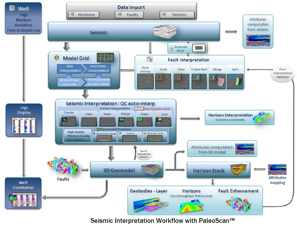
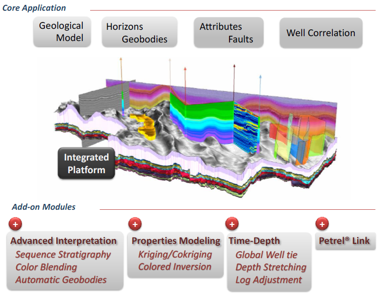
PaleoScan™ Core includes all the necessary to run a comprehensive workflow, from data loading to generation of interpreted objects. It is a new generation of 3D seismic interpretation platform, offering in a user friendly environment rapid data screening and cross navigation. PaleoScan™ offers a comprehensive approach to semi-automatically interpret seismic volumes, in addition to the standard interpretation tools for horizons, faults and multi-Z objects. Thanks to powerful editing tools, the interpretation can be refined and the geological model can be previewed in real time. A suite of applications allows the generation of horizons, the stratal-slicing of volumes, the extraction and quantification of geobodies, the enhancement and characterization of faults, and the cross correlation of wells and markers. PaleoScan™ takes also advantage of parallel computing with the latest multi-core technologies
This method uses comprehensive approach which consists of a three-step computer aided workflow. Our algorithm tracks first every possible horizon within the seismic volume and assign relative geological ages automatically. Then the interpreter edits relationships between horizons and update the model in real time to obtain the optimum solution. Based on the horizon grid, a geological time volume is computed from the seismic
Comprehensive approach-
Initial grid made of horizon patches-
Manage peak, trough, zero crossing and inflection points-
Automatic horizon tracking-
Chronostratigraphic ordering-
Multi scale method-
Work on large data set for exploration-
Manage fault-horizon intersection-
Fast and interactive editing-
Model preview in real time-
تیم PetroTools این نرم افزار را برای شما ارائه می دهد. جهت تهیه نرم افزار با استفاده از منوی خرید با ما در تماس باشید
For buy software, Please contact us via buy menu